Accessibility issues and needs that were identified
-
providing means for older adults to participate in urban planning;
-
solve accessibility/mobility issues by collecting, visualising and sharing relevant, up to date and area specific data to inform decision making;
-
create datasets of interesting and enjoyable places to assist in future planning efforts;
-
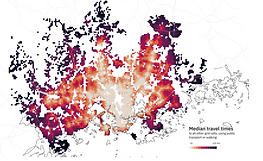
measuring travel-time in Helsinki region considering needs of older citizens.
Solutions to these needs will be piloted with the following three use cases:
-
feedback on accessibility issues - piloted in Vuosaari
-
point of Interest - piloted in Vuosaari
-
travel-Time Matrix - piloted in the whole metropolitan area
Accessibility issues and needs that were identified
-
providing means for older adults to participate in urban planning;
-
solve accessibility/mobility issues by collecting, visualising and sharing relevant, up to date and area specific data to inform decision making;
-
create datasets of interesting and enjoyable places to assist in future planning efforts;
-
measuring travel-time in Helsinki region considering needs of older citizens.
Solutions to these needs will be piloted with the following three use cases:
-
feedback on accessibility issues - piloted in Vuosaari
-
point of Interest - piloted in Vuosaari
-
travel-Time Matrix - piloted in the whole metropolitan area
technology approach
architecture. integration. platform

technology approach

URBANAGE
ECOSYSTEM FOR URBAN PLANNING

The open URBANAGE platform provides a range of data-based visualisation tools and analytical services which make it easier to understand the complex interrelation between urban factors and expected impacts of potential changes on the population, especially older residents. This intelligence helps you make better evidence-based planning, operational decisions and longer term policy choices to create more liveable, accessible and inclusive age-friendly cities that work for all.
Improved Planning
Make planning decisions based on a unified view of urban situations with older people's real needs based on participatory data collection and predictive simulations
Better Citizen Experience
Act quickly and seamlessly on the real needs of older citizens, better interact with them and help people understand why certain planning or operational decisions have been made
Increased value for money
Experiment with different planning options online, exploring impacts by simulating various scenarios, rather than running multiple costly on-the-ground pilots


URBANAGE Services
Age-Friendly Route Planner - helps citizens navigate the city via routes calculated on personal preferences
Older Adult Engagement Practices for Age-Friendly Cities - inclusive participatory process using engagements tools and methods suited for older adults, leveraging the potential of gamification techniques, as well as for civil servants, organised in the three pilot cities/region in order to address, not only the design of the URBANAGE Ecosystem but also the policy-related aspects resulting from URBANAGE
City Digital Twin for Age-Friendly Urban Planning - The URBANAGE Digital Twin is an extensible platform which allows modeling the city and its processes through a virtual replica
Age Friendliness Index & URBANAGE Age Friendly City Indicators Framework - explore and compare the age-friendliness of neighbourhoods
Green Comfort Model - crowdsource information about the green comfort of spaces and simulate improvements
Lessons Learned for Urban Planning
Check out the most important lessons learned compiled by the URBANAGE consortium.
More Information

Platform Architecture
Make planning decisions based on a unified view of urban situations with older people's real needs based on participatory data collection and predictive simulations
Digital Twins
Act quickly and seamlessly on the real needs of older citizens, better interact with them and help people understand why certain planning or operational decisions have been made